Metal Print > Arts > Artists > O > Oceanic Oceanic
Metal Print : EXPL2A-00352


Metal Prints from North Wind
EXPL2A-00352
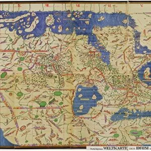
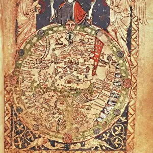
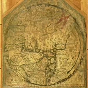
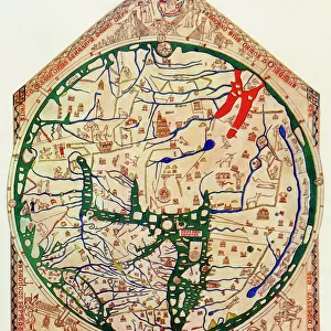
The Hereford Mappa Mundi of 1280 - Jerusalem is at the center, Europe lower left, Africa lower right.
Printed color halftone reproduction 19th century
North Wind Picture Archives brings history to life with stock images and hand-colored illustrations
Media ID 5881938
© North Wind Picture Archives
1200s 13th Century Africa Asia Cartography Document Earth Europe Flat Earth Jerusalem Medieval Mediterranean Mid East Middle Ages Navigation Ocean World World Map 1280 Flat Hereford Mappa Mundi
16"x20" (51x41cm) Metal Print
Discover the rich history and intricate details of the Hereford Mappa Mundi with our Media Storehouse Metal Prints. Featuring EXPL2A-00352 from North Wind Picture Archives, this captivating image showcases the 13th-century world map from Hereford, England. With Jerusalem at the center, Europe to the lower left, and Africa to the lower right, this 19th-century color halftone reproduction brings history to life. Our high-quality Metal Prints offer vibrant colors, stunning clarity, and a modern, sleek design that adds a unique touch to any space. Experience the past in a whole new way with Media Storehouse.
Made with durable metal and luxurious printing techniques, our metal photo prints go beyond traditional canvases, adding a cool, modern touch to your space. Wall mount on back. Eco-friendly 100% post-consumer recycled ChromaLuxe aluminum surface. The thickness of the print is 0.045". Featuring a Scratch-resistant surface and Rounded corners. Backing hangers are attached to the back of the print and float the print 1/2-inch off the wall when hung, the choice of hanger may vary depending on size and International orders will come with Float Mount hangers only. Finished with a brilliant white high gloss surface for unsurpassed detail and vibrance. Printed using Dye-Sublimation and for best care we recommend a non-ammonia glass cleaner, water, or isopropyl (rubbing) alcohol to prevent harming the print surface. We recommend using a clean, lint-free cloth to wipe off the print. The ultra-hard surface is scratch-resistant, waterproof and weatherproof. Avoid direct sunlight exposure.
Made with durable metal and luxurious printing techniques, metal prints bring images to life and add a modern touch to any space
Estimated Image Size (if not cropped) is 40.6cm x 46.6cm (16" x 18.3")
Estimated Product Size is 41.2cm x 51.4cm (16.2" x 20.2")
These are individually made so all sizes are approximate
Artwork printed orientated as per the preview above, with portrait (vertical) orientation to match the source image.
FEATURES IN THESE COLLECTIONS
> Arts
> Art Movements
> Medieval Art
> Arts
> Artists
> O
> Oceanic Oceanic
> Maps and Charts
> Flat Earth
> Maps and Charts
> Popular Maps
> Maps and Charts
> Related Images
> Maps and Charts
> World
> Popular Themes
> Maps and Charts
> North Wind Picture Archives
> Maps
EDITORS COMMENTS
This print showcases the EXPL2A-00352, also known as The Hereford Mappa Mundi of 1280. A true testament to medieval cartography, this vintage reproduction offers a glimpse into the world as it was perceived in the 13th century. At its heart lies Jerusalem, symbolizing its significance during that era. Europe is depicted in the lower left corner, while Africa graces the lower right side of this historic map. Printed with vibrant colors and halftone techniques in the 19th century, this illustration transports us back to a time when navigation relied on such intricate documents. The detailed representation of continents and oceans serves as a reminder of how early civilizations understood their place within the vastness of our planet. The Hereford Mappa Mundi not only provides geographical information but also reflects cultural beliefs prevalent during the Middle Ages. It captures an Earth where Asia stretches eastward towards unknown lands and where mythical creatures roam unexplored territories. As we gaze upon this remarkable piece of artistry, we are reminded of humanity's insatiable curiosity about our world's history and geography. This photograph invites us to appreciate both its aesthetic beauty and historical significance—a tangible connection to an age long past yet still relevant today.
MADE IN THE USA
Safe Shipping with 30 Day Money Back Guarantee
FREE PERSONALISATION*
We are proud to offer a range of customisation features including Personalised Captions, Color Filters and Picture Zoom Tools
SECURE PAYMENTS
We happily accept a wide range of payment options so you can pay for the things you need in the way that is most convenient for you
* Options may vary by product and licensing agreement. Zoomed Pictures can be adjusted in the Cart.