Fine Art Print > Europe > United Kingdom > England > London > Towns > Welling
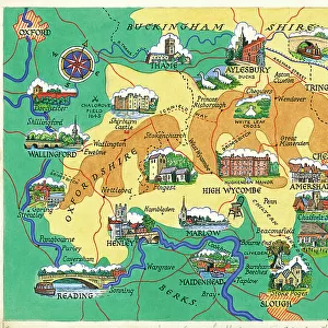
Fine Art Print : Old Map of the Environs of London 1836 by Thomas Moule


![]()
Fine Art Prints from MapSeeker
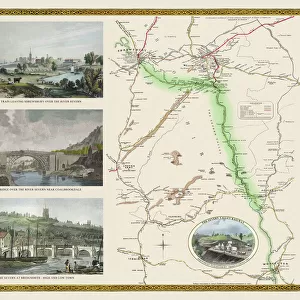
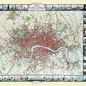
Old Map of the Environs of London 1836 by Thomas Moule
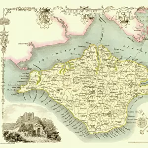
This is a fine decorative reproduction Map of The Environs of London from the First Edition series of Thomas Moule Maps, originally Published in 1836. The well-known series of County Maps which are known as Moules feature beautiful vignette views, there were also 4 " Environs" Maps included, and were first published in separate sections for each county in 1830-32, they were then published in collected form in a two-volume work: The English Counties Delineated: or a Topographical Description of England: Illustrated by a Complete Series of County Maps by Thomas Moule: London: Published by George Virtue 1836
Welcome to the Mapseeker Image library and enter an historic gateway to one of the largest on-line collections of Historic Maps, Nostalgic Views, Vista's and Panorama's from a World gone by.
Media ID 20348235
© Mapseeker Publishing Ltd
Historic Map London Map Map Of London Moule Map Old Moule Map Thomas Moule Thomas Moule Map Environs Of London
20"x16" (+3" Border) Fine Art Print
Step back in time with our exquisite Old Map of the Environs of London 1836 by Thomas Moule from our Fine Art Prints collection at Media Storehouse. This decorative reproduction map, published originally by Thomas Moule and George Virtue in 1836, offers a captivating glimpse into the history and layout of London over 180 years ago. Meticulously printed on high-quality archival paper, this fine art print is a must-have for history enthusiasts, map collectors, and anyone who appreciates the beauty of vintage cartography. Add a touch of historical charm to your home or office with this stunning Old Map of the Environs of London 1836 by Thomas Moule from Media Storehouse.
20x16 image printed on 26x22 Fine Art Rag Paper with 3" (76mm) white border. Our Fine Art Prints are printed on 300gsm 100% acid free, PH neutral paper with archival properties. This printing method is used by museums and art collections to exhibit photographs and art reproductions.
Our fine art prints are high-quality prints made using a paper called Photo Rag. This 100% cotton rag fibre paper is known for its exceptional image sharpness, rich colors, and high level of detail, making it a popular choice for professional photographers and artists. Photo rag paper is our clear recommendation for a fine art paper print. If you can afford to spend more on a higher quality paper, then Photo Rag is our clear recommendation for a fine art paper print.
Estimated Image Size (if not cropped) is 50.8cm x 40.6cm (20" x 16")
Estimated Product Size is 66cm x 55.9cm (26" x 22")
These are individually made so all sizes are approximate
Artwork printed orientated as per the preview above, with landscape (horizontal) orientation to match the source image.
FEATURES IN THESE COLLECTIONS
> Arts
> Artists
> M
> Thomas Moule
> Europe
> United Kingdom
> England
> London
> Towns
> Welling
> Europe
> United Kingdom
> England
> Maps
> Europe
> United Kingdom
> England
> Wells
> MapSeeker
> British Town And City Plans
> English & Welsh PORTFOLIO
EDITORS COMMENTS
This stunning print showcases the "Old Map of the Environs of London 1836" by Thomas Moule, a renowned cartographer from the 19th century. Originally published in 1836 as part of Moule's series of County Maps, this particular map focuses on the surrounding areas of London. The intricate details and exquisite craftsmanship make this decorative reproduction a true work of art. The map features beautiful vignette views that add charm and character to its overall design. It is evident that Moule had a deep appreciation for both accuracy and aesthetics when creating his maps. Published by George Virtue in 1836, this map was part of a larger two-volume work titled "The English Counties Delineated: or a Topographical Description of England". This comprehensive collection included not only county maps but also four additional "Environs" maps like the one displayed here. As you explore this historic map, you can't help but be transported back in time to early 19th-century London. Every street, river, and landmark is meticulously depicted, offering a glimpse into what life was like during that era. Whether you are an avid history enthusiast or simply appreciate fine artistry, this print captures the essence and beauty of Thomas Moule's iconic cartography. Display it proudly in your home or office to admire its rich historical significance and timeless appeal.
MADE IN THE USA
Safe Shipping with 30 Day Money Back Guarantee
FREE PERSONALISATION*
We are proud to offer a range of customisation features including Personalised Captions, Color Filters and Picture Zoom Tools
SECURE PAYMENTS
We happily accept a wide range of payment options so you can pay for the things you need in the way that is most convenient for you
* Options may vary by product and licensing agreement. Zoomed Pictures can be adjusted in the Cart.