Home > North America > United States of America > Georgia > Savannah
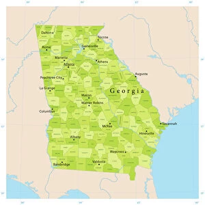
1874 U.S. Coast Survey Map Or Chart Of The Georgia And Carolina Coast

![]()
Wall Art and Photo Gifts from Universal Images Group (UIG)
1874 U.S. Coast Survey Map Or Chart Of The Georgia And Carolina Coast
1874, U.S. Coast Survey Map or Chart of the Georgia and Carolina Coast, Charleston and Savannah
Universal Images Group (UIG) manages distribution for many leading specialist agencies worldwide
Media ID 38549920
© Artokoloro Quint Lox Limited
1874 Antique Map Latitude Longitude Mappa Mundi Old Antique Plan Old Antique View Ols Antique Map Rare Old Maps Topo
FEATURES IN THESE COLLECTIONS
> Asia
> Georgia
> Related Images
> Europe
> France
> Canton
> Landes
> Historic
> Space exploration
> Maps and Charts
> Early Maps
> Maps and Charts
> Related Images
> Maps and Charts
> World
> North America
> United States of America
> Georgia
> Savannah
> Universal Images Group (UIG)
> History
> Historical Maps
EDITORS COMMENTS
Step back in time to the late 19th century with this stunning print of the 1874 U.S. Coast Survey Map or Chart of the Georgia and Carolina Coast, Charleston and Savannah. This beautifully rendered map is a testament to the meticulous work of cartographers who meticulously charted the coastal regions of America during a time of great exploration and discovery.
The intricate details on this vintage map reveal a world that was once unknown, with lush forests, winding rivers, and bustling ports marked by tiny illustrations. The grid-like pattern provides a sense of order and precision, while the subtle shading adds depth and texture to the landscape.
This historic map is not only a fascinating piece of geographical history but also an artistic masterpiece. The aged paper has developed a warm patina over time, giving it an air of nostalgia and character. It's as if you can almost smell the salty sea air wafting from its creases.
Imagine being one of those brave explorers who set sail across these waters centuries ago, navigating through treacherous shoals and hidden coves in search of new lands. This map is more than just a piece of paper - it's a window into our collective past, inviting us to explore, discover, and dream.
MADE IN THE USA
Safe Shipping with 30 Day Money Back Guarantee
FREE PERSONALISATION*
We are proud to offer a range of customisation features including Personalised Captions, Color Filters and Picture Zoom Tools
SECURE PAYMENTS
We happily accept a wide range of payment options so you can pay for the things you need in the way that is most convenient for you
* Options may vary by product and licensing agreement. Zoomed Pictures can be adjusted in the Cart.