Home > Europe > France > Canton > Landes
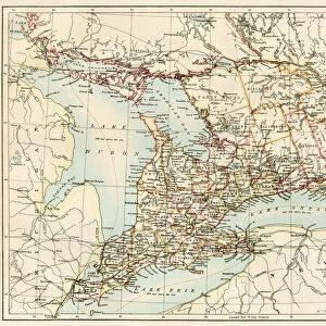
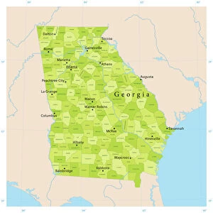
1864 Mitchell Map Of Georgia And Alabama Topography

![]()
Wall Art and Photo Gifts from Universal Images Group (UIG)
1864 Mitchell Map Of Georgia And Alabama Topography
1864, Mitchell Map of Georgia and Alabama
Universal Images Group (UIG) manages distribution for many leading specialist agencies worldwide
Media ID 38551656
© Artokoloro Quint Lox Limited
1864 Antique Map Latitude Longitude Mappa Mundi Old Antique Plan Old Antique View Ols Antique Map Rare Old Maps Topo
FEATURES IN THESE COLLECTIONS
> Asia
> Georgia
> Related Images
> Europe
> France
> Canton
> Landes
> Historic
> Space exploration
> Maps and Charts
> Early Maps
> Maps and Charts
> Related Images
> Maps and Charts
> World
> Universal Images Group (UIG)
> History
> Historical Maps
EDITORS COMMENTS
Step back in time to the midst of the American Civil War with this stunning print of the 1864 Mitchell Map of Georgia and Alabama Topography. Created by renowned cartographer Samuel Augustus Mitchell, this vintage map provides a fascinating glimpse into the geography and topography of these two southern states during a pivotal moment in American history.
The intricate illustration is filled with detailed information about mountains, rivers, cities, and towns, showcasing the region's natural features and human settlements. The map also highlights key military routes, forts, and battlefields from the war-torn landscape.
This beautiful piece of cartographic art is not only a valuable historical resource but also a striking decorative addition to any room. Its aged appearance adds an air of nostalgia and charm, making it perfect for framing or displaying as a unique conversation starter.
Whether you're an historian, geography enthusiast, or simply someone who appreciates vintage aesthetics, this 1864 Mitchell Map of Georgia and Alabama Topography is sure to captivate your imagination. Take a journey through time and explore the rich cultural heritage preserved within its borders.
MADE IN THE USA
Safe Shipping with 30 Day Money Back Guarantee
FREE PERSONALISATION*
We are proud to offer a range of customisation features including Personalised Captions, Color Filters and Picture Zoom Tools
SECURE PAYMENTS
We happily accept a wide range of payment options so you can pay for the things you need in the way that is most convenient for you
* Options may vary by product and licensing agreement. Zoomed Pictures can be adjusted in the Cart.