Home > North America > United States of America > Georgia > Savannah
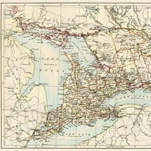
1855 Colton Plan Or Map Of Charleston South Carolina And Savannah

![]()
Wall Art and Photo Gifts from Universal Images Group (UIG)
1855 Colton Plan Or Map Of Charleston South Carolina And Savannah
1855, Colton Plan or Map of Charleston, South Carolina and Savannah, Georgia
Universal Images Group (UIG) manages distribution for many leading specialist agencies worldwide
Media ID 38549106
© Artokoloro Quint Lox Limited
1855 Georgia Antique Map Latitude Longitude Mappa Mundi Old Antique Plan Old Antique View Ols Antique Map Rare Old Maps Topo
FEATURES IN THESE COLLECTIONS
> Asia
> Georgia
> Related Images
> Europe
> France
> Canton
> Landes
> Historic
> Space exploration
> Maps and Charts
> Early Maps
> Maps and Charts
> Related Images
> Maps and Charts
> World
> North America
> United States of America
> Georgia
> Savannah
> North America
> United States of America
> South Carolina
> Charleston
> Universal Images Group (UIG)
> History
> Historical Maps
EDITORS COMMENTS
Step back in time to the mid-19th century with this stunning print of a 1855 Colton Plan or Map of Charleston, South Carolina and Savannah, Georgia. This beautifully rendered map showcases the intricate details of these two historic cities during a pivotal moment in American history.
The map is a testament to the cartographic skills of Joseph Hutchins Colton, one of the most prominent mapmakers of his era. The level of precision and accuracy is remarkable, with carefully drawn borders, roads, rivers, and buildings that give us a glimpse into life in these Southern cities before the Civil War.
From the bustling streets of Charleston's Market Square to the picturesque architecture of Savannah's Historic District, every detail on this map tells a story. Take note of the slave markets and plantations scattered throughout both cities - a poignant reminder of the complex social dynamics at play during this period.
This vintage print is not only an impressive piece for any collector or historian but also serves as a powerful tool for exploring our shared cultural heritage. It invites us to reflect on how far we've come since then and how much remains unchanged despite significant progress towards equality and justice.
Hang it proudly in your home or office as a conversation starter that sparks curiosity about our collective past.
MADE IN THE USA
Safe Shipping with 30 Day Money Back Guarantee
FREE PERSONALISATION*
We are proud to offer a range of customisation features including Personalised Captions, Color Filters and Picture Zoom Tools
SECURE PAYMENTS
We happily accept a wide range of payment options so you can pay for the things you need in the way that is most convenient for you
* Options may vary by product and licensing agreement. Zoomed Pictures can be adjusted in the Cart.