Home > Europe > France > Canton > Landes
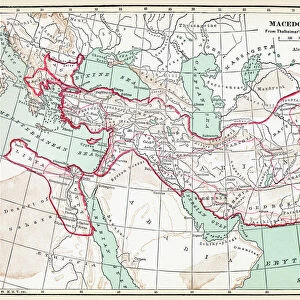
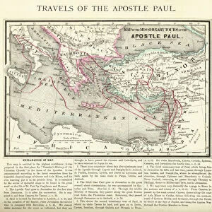
1855 Colton Map Of Turkey In Europe Macedonia

![]()
Wall Art and Photo Gifts from Universal Images Group (UIG)
1855 Colton Map Of Turkey In Europe Macedonia
1855, Colton Map of Turkey in Europe, Macedonia, and the Balkans
Universal Images Group (UIG) manages distribution for many leading specialist agencies worldwide
Media ID 38549096
© Artokoloro Quint Lox Limited
1855 Macedonia Antique Map Latitude Longitude Mappa Mundi Old Antique Plan Old Antique View Ols Antique Map Rare Old Maps Topo
FEATURES IN THESE COLLECTIONS
> Asia
> Turkey
> Related Images
> Europe
> France
> Canton
> Landes
> Europe
> Macedonia
> Related Images
> Historic
> Space exploration
> Maps and Charts
> Early Maps
> Maps and Charts
> North Macedonia
> Maps and Charts
> Related Images
> Maps and Charts
> World
> Universal Images Group (UIG)
> History
> Historical Maps
EDITORS COMMENTS
Step back in time to the mid-19th century with this stunning 1855 Colton Map of Turkey in Europe, Macedonia, and the Balkans. This beautifully rendered illustration not only showcases the geographical boundaries of these regions but also provides a glimpse into the historical context of the era.
The map is a masterpiece of cartography, featuring intricate details such as mountain ranges, rivers, and cities. The region's complex political landscape is also depicted, highlighting the various territories and empires that existed at the time. From ancient trade routes to modern-day borders, this map offers a fascinating look at how our understanding of geography has evolved over time.
As you gaze upon this vintage print, imagine yourself on a journey through history - traversing dusty trails alongside merchants and travelers who once navigated these lands. The worn edges and yellowed paper add an air of authenticity to this piece, making it feel like a treasured artifact from another era.
This map is not just a visual representation of geography; it's a window into the past - revealing secrets about cultures, empires, and civilizations that have shaped our world today.
MADE IN THE USA
Safe Shipping with 30 Day Money Back Guarantee
FREE PERSONALISATION*
We are proud to offer a range of customisation features including Personalised Captions, Color Filters and Picture Zoom Tools
SECURE PAYMENTS
We happily accept a wide range of payment options so you can pay for the things you need in the way that is most convenient for you
* Options may vary by product and licensing agreement. Zoomed Pictures can be adjusted in the Cart.