Home > Europe > France > Canton > Landes
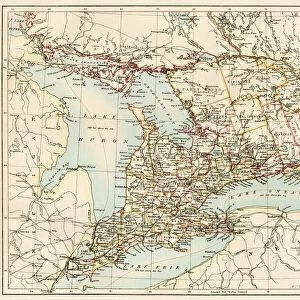
1855 Colton Map Of Georgia Topography Cartography

![]()
Wall Art and Photo Gifts from Universal Images Group (UIG)
1855 Colton Map Of Georgia Topography Cartography
1855, Colton Map of Georgia
Universal Images Group (UIG) manages distribution for many leading specialist agencies worldwide
Media ID 38551196
© Artokoloro Quint Lox Limited
1855 Antique Map Latitude Longitude Mappa Mundi Old Antique Plan Old Antique View Ols Antique Map Rare Old Maps Topo
FEATURES IN THESE COLLECTIONS
> Asia
> Georgia
> Related Images
> Europe
> France
> Canton
> Landes
> Historic
> Space exploration
> Maps and Charts
> Early Maps
> Maps and Charts
> Related Images
> Maps and Charts
> World
> Universal Images Group (UIG)
> History
> Historical Maps
EDITORS COMMENTS
Step back in time and explore the rugged terrain of Georgia with this stunning 1855 Colton Map of Georgia Topography Cartography. This vintage map is a masterpiece of geographic illustration, showcasing the state's diverse landscape with intricate detail and precision.
The map features a beautiful hand-colored topographic representation of Georgia, highlighting its mountains, rivers, lakes, and cities. The cartographer's skillful use of shading and hatching creates a sense of depth and dimensionality, drawing the viewer into the rolling hills and valleys.
This historic map is not only a testament to the artistry of 19th-century cartography but also provides valuable insight into the geography and settlement patterns of Georgia during that era. It would be an excellent addition to any collection or study related to American history, geography, or vintage maps.
Printed on high-quality paper using traditional techniques, this reproduction captures every nuance and detail from the original map. The result is a beautiful piece that will delight historians, collectors, and anyone fascinated by the intersection of art and science.
MADE IN THE USA
Safe Shipping with 30 Day Money Back Guarantee
FREE PERSONALISATION*
We are proud to offer a range of customisation features including Personalised Captions, Color Filters and Picture Zoom Tools
SECURE PAYMENTS
We happily accept a wide range of payment options so you can pay for the things you need in the way that is most convenient for you
* Options may vary by product and licensing agreement. Zoomed Pictures can be adjusted in the Cart.