Home > North America > United States of America > Georgia > Savannah
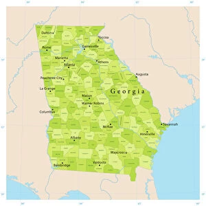
1854 U.S. Coast Survey Chart Or Map Of The Savannah River Ans Savannah

![]()
Wall Art and Photo Gifts from Universal Images Group (UIG)
1854 U.S. Coast Survey Chart Or Map Of The Savannah River Ans Savannah
1854, U.S. Coast Survey Chart or Map of the Savannah River ans Savannah, Georgia
Universal Images Group (UIG) manages distribution for many leading specialist agencies worldwide
Media ID 38549024
© Artokoloro Quint Lox Limited
1854 Georgia Antique Map Latitude Longitude Mappa Mundi Old Antique Plan Old Antique View Ols Antique Map Rare Old Maps Topo
FEATURES IN THESE COLLECTIONS
> Asia
> Georgia
> Related Images
> Europe
> France
> Canton
> Landes
> Historic
> Space exploration
> Maps and Charts
> Early Maps
> Maps and Charts
> Related Images
> Maps and Charts
> World
> North America
> United States of America
> Georgia
> Savannah
> Universal Images Group (UIG)
> History
> Historical Maps
EDITORS COMMENTS
Step back in time to the mid-19th century with this stunning 1854 U.S. Coast Survey Chart or Map of the Savannah River and Savannah, Georgia. This beautifully preserved print is a treasure trove of geographic and historical significance, offering a glimpse into the region's rich past.
The map showcases the intricate details of the Savannah River, its tributaries, and surrounding landscape, providing valuable information for navigators and explorers alike. The chart also highlights key landmarks, such as Fort Pulaski National Monument and the city of Savannah itself.
This vintage map is not only a fascinating piece of cartography but also an important artifact that reflects the growth and development of our understanding of geography during this period. The meticulous attention to detail and artistic flair evident in this print make it a true masterpiece.
Whether you're a history buff, geography enthusiast, or simply someone who appreciates beautiful artistry on paper, this 1854 U.S. Coast Survey Chart or Map of the Savannah River ans Savannah is sure to captivate your imagination.
MADE IN THE USA
Safe Shipping with 30 Day Money Back Guarantee
FREE PERSONALISATION*
We are proud to offer a range of customisation features including Personalised Captions, Color Filters and Picture Zoom Tools
SECURE PAYMENTS
We happily accept a wide range of payment options so you can pay for the things you need in the way that is most convenient for you
* Options may vary by product and licensing agreement. Zoomed Pictures can be adjusted in the Cart.