Home > Europe > France > Canton > Landes
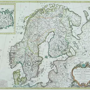
1850 Mitchell Map Of Scandinavia Norway Sweden

![]()
Wall Art and Photo Gifts from Universal Images Group (UIG)
1850 Mitchell Map Of Scandinavia Norway Sweden
1850, Mitchell Map of Scandinavia, Norway, Sweden, Denmark, Finland
Universal Images Group (UIG) manages distribution for many leading specialist agencies worldwide
Media ID 38548689
© Artokoloro Quint Lox Limited
1850 Denmark Finland Norway Sweden Antique Map Latitude Longitude Mappa Mundi Old Antique Plan Old Antique View Ols Antique Map Rare Old Maps Topo
FEATURES IN THESE COLLECTIONS
> Europe
> Denmark
> Related Images
> Europe
> Finland
> Related Images
> Europe
> France
> Canton
> Landes
> Europe
> Norway
> Related Images
> Europe
> Sweden
> Related Images
> Historic
> Space exploration
> Universal Images Group (UIG)
> History
> Historical Maps
EDITORS COMMENTS
Step back in time to the mid-19th century with this stunning 1850 Mitchell Map of Scandinavia, Norway, Sweden, Denmark, and Finland. This vintage print is a treasure trove of geographical information, showcasing the region's topography and cartography in exquisite detail.
The map is a testament to the meticulous work of Samuel Augustus Mitchell Jr., an American cartographer who was renowned for his accurate and beautifully illustrated maps. The intricate design features a grid layout with latitude and longitude lines, allowing explorers to navigate the region with ease.
This historic map is not only a fascinating piece of geography but also a beautiful work of art. The illustration style is reminiscent of ancient mappa mundi, with ornate borders and decorative elements that add to its charm. The paper has aged beautifully over time, giving it a warm patina that adds character to the overall design.
Whether you're an avid traveler or simply fascinated by history and geography, this 1850 Mitchell Map of Scandinavia is sure to captivate your imagination. It's a unique piece that would make an excellent addition to any room or collection.
MADE IN THE USA
Safe Shipping with 30 Day Money Back Guarantee
FREE PERSONALISATION*
We are proud to offer a range of customisation features including Personalised Captions, Color Filters and Picture Zoom Tools
SECURE PAYMENTS
We happily accept a wide range of payment options so you can pay for the things you need in the way that is most convenient for you
* Options may vary by product and licensing agreement. Zoomed Pictures can be adjusted in the Cart.