Home > Europe > France > Canton > Landes
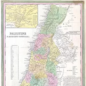
1836 Tanner Map Of Palestine Israel Holy Land

Wall Art and Photo Gifts from Universal Images Group (UIG)
1836 Tanner Map Of Palestine Israel Holy Land
1836, Tanner Map of Palestine, Israel, Holy Land
Universal Images Group (UIG) manages distribution for many leading specialist agencies worldwide
Media ID 38550826
© Artokoloro Quint Lox Limited
1836 Holy Land Israel Antique Map Latitude Longitude Mappa Mundi Old Antique Plan Old Antique View Ols Antique Map Rare Old Maps Topo
FEATURES IN THESE COLLECTIONS
> Asia
> Israel
> Related Images
> Asia
> Palestine
> Related Images
> Europe
> France
> Canton
> Landes
> Historic
> Space exploration
> Maps and Charts
> Early Maps
> Maps and Charts
> Related Images
> Maps and Charts
> World
> Universal Images Group (UIG)
> History
> Historical Maps
EDITORS COMMENTS
Step back in time to the 19th century with this stunning print of the Tanner Map of Palestine, Israel, and the Holy Land from 1836. This vintage map is a remarkable piece of cartography that showcases the region's topography and geography during a pivotal moment in history.
Created by John Tanner, an American cartographer, this map is a testament to his skill and attention to detail. The intricate illustration features mountains, valleys, rivers, and cities, providing a comprehensive view of the region's landscape. From Jerusalem to Bethlehem, Nazareth to Gaza, every notable location is meticulously mapped out.
This historic map not only serves as a fascinating piece of geographical art but also offers insight into the cultural and religious significance of the region during that era. It's a window into a bygone era when explorers like Tanner were charting new territories and documenting their findings for future generations.
The aged paper has developed a beautiful patina over time, giving this print an air of nostalgia and character. Whether you're an historian, geographer or simply someone who appreciates vintage maps, this print is sure to captivate your imagination.
MADE IN THE USA
Safe Shipping with 30 Day Money Back Guarantee
FREE PERSONALISATION*
We are proud to offer a range of customisation features including Personalised Captions, Color Filters and Picture Zoom Tools
SECURE PAYMENTS
We happily accept a wide range of payment options so you can pay for the things you need in the way that is most convenient for you
* Options may vary by product and licensing agreement. Zoomed Pictures can be adjusted in the Cart.