Home > Europe > France > Canton > Landes
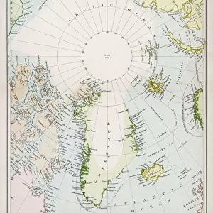
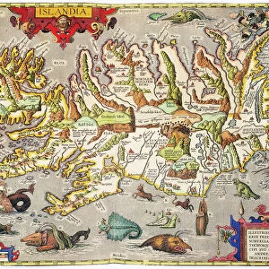
1833 Malte-Brun Map Of Denmark Iceland And Faeroe Islands

![]()
Wall Art and Photo Gifts from Universal Images Group (UIG)
1833 Malte-Brun Map Of Denmark Iceland And Faeroe Islands
1833, Malte-Brun Map of Denmark, Iceland and Faeroe Islands
Universal Images Group (UIG) manages distribution for many leading specialist agencies worldwide
Media ID 38548563
© Artokoloro Quint Lox Limited
1833 Antique Map Latitude Longitude Mappa Mundi Old Antique Plan Old Antique View Ols Antique Map Rare Old Maps Topo
FEATURES IN THESE COLLECTIONS
> Europe
> Denmark
> Related Images
> Europe
> France
> Canton
> Landes
> Europe
> Iceland
> Related Images
> Historic
> Space exploration
> Maps and Charts
> Early Maps
> Maps and Charts
> Related Images
> Universal Images Group (UIG)
> History
> Historical Maps
EDITORS COMMENTS
Step back in time to the early 19th century with this stunning print of the 1833 Malte-Brun Map of Denmark, Iceland, and Faeroe Islands. This beautifully detailed illustration is a testament to the cartographic skills of French geographer Conrad Malte-Brun, who was renowned for his meticulous attention to detail and commitment to accuracy.
This vintage map showcases the region's topography, featuring intricate illustrations of mountains, rivers, and coastlines. The map also includes information on latitude and longitude coordinates, providing a fascinating glimpse into the geographical knowledge of the era.
The print is not only a beautiful piece of art but also a valuable historical artifact that offers insight into how our understanding of geography has evolved over time. It's a must-have for anyone interested in cartography, geography, or history.
Whether you're an avid traveler or simply appreciate vintage maps as works of art, this print is sure to captivate your imagination. Its aged appearance adds character and charm to any room or office decor.
MADE IN THE USA
Safe Shipping with 30 Day Money Back Guarantee
FREE PERSONALISATION*
We are proud to offer a range of customisation features including Personalised Captions, Color Filters and Picture Zoom Tools
SECURE PAYMENTS
We happily accept a wide range of payment options so you can pay for the things you need in the way that is most convenient for you
* Options may vary by product and licensing agreement. Zoomed Pictures can be adjusted in the Cart.