Home > Europe > United Kingdom > Scotland > Maps
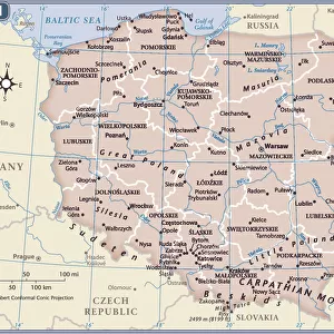
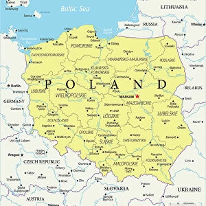
1818 Pinkerton Map Of Poland John Pinkerton 1758 – 1826

![]()
Wall Art and Photo Gifts from Universal Images Group (UIG)
1818 Pinkerton Map Of Poland John Pinkerton 1758 – 1826
1818, Pinkerton Map of Poland, John Pinkerton, 1758 - 1826, Scottish antiquarian, cartographer, UK
Universal Images Group (UIG) manages distribution for many leading specialist agencies worldwide
Media ID 38550706
© Artokoloro Quint Lox Limited
1758 – 1826 1818 Cartographer John Pinkerton Scottish Antiquarian Antique Map Latitude Longitude Mappa Mundi Old Antique Plan Old Antique View Ols Antique Map Rare Old Maps Topo
FEATURES IN THESE COLLECTIONS
> Europe
> France
> Canton
> Landes
> Europe
> Poland
> Related Images
> Europe
> United Kingdom
> Maps
> Europe
> United Kingdom
> Scotland
> Maps
> Europe
> United Kingdom
> Scotland
> Related Images
> Historic
> Space exploration
> Maps and Charts
> Early Maps
> Maps and Charts
> Related Images
> Universal Images Group (UIG)
> History
> Historical Maps
EDITORS COMMENTS
Step back in time and explore the intricate details of 19th-century cartography with this stunning print of John Pinkerton's 1818 map of Poland. As a renowned Scottish antiquarian and cartographer, Pinkerton's work is a testament to his dedication to geographic exploration and mapping. This vintage print showcases the region's topography, featuring detailed illustrations of mountains, rivers, cities, and towns.
Pinkerton's meticulous attention to detail is evident in the precise rendering of latitude and longitude lines, as well as the inclusion of various symbols denoting different types of terrain. The map also highlights key geographical features such as forests, swamps, and lakes.
This beautiful piece would make a unique addition to any room or office space that celebrates history, geography, or travel. It serves as a reminder of the importance of cartography in understanding our world and its many wonders. Whether you're an avid historian or simply appreciate the artistry involved in creating these ancient maps, this print is sure to captivate your imagination.
MADE IN THE USA
Safe Shipping with 30 Day Money Back Guarantee
FREE PERSONALISATION*
We are proud to offer a range of customisation features including Personalised Captions, Color Filters and Picture Zoom Tools
SECURE PAYMENTS
We happily accept a wide range of payment options so you can pay for the things you need in the way that is most convenient for you
* Options may vary by product and licensing agreement. Zoomed Pictures can be adjusted in the Cart.