Home > Europe > France > Canton > Landes
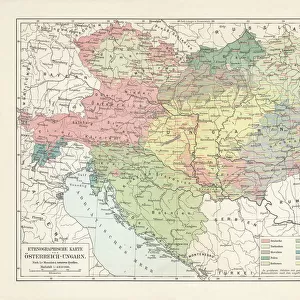
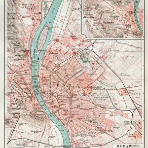
1799 Cary Map Of Hungary Croatia And Transylvania

![]()
Wall Art and Photo Gifts from Universal Images Group (UIG)
1799 Cary Map Of Hungary Croatia And Transylvania
1799, Cary Map of Hungary, Croatia and Transylvania, John Cary, 1754 - 1835, was an English cartographer, John Cary, 1754 - 1835, English cartographer
Universal Images Group (UIG) manages distribution for many leading specialist agencies worldwide
Media ID 38548293
© Artokoloro Quint Lox Limited
1754 – 1835 1799 English Cartographer John Cary Was An English Cartographer Antique Map Latitude Longitude Mappa Mundi Old Antique Plan Old Antique View Ols Antique Map Rare Old Maps Topo
FEATURES IN THESE COLLECTIONS
> Europe
> Croatia
> Related Images
> Europe
> France
> Canton
> Landes
> Europe
> Hungary
> Related Images
> Historic
> Space exploration
> Maps and Charts
> Early Maps
> Maps and Charts
> Related Images
> Universal Images Group (UIG)
> History
> Historical Maps
EDITORS COMMENTS
Step back in time to the late 18th century with this stunning print of John Cary's 1799 map of Hungary, Croatia, and Transylvania. This beautifully crafted illustration is a testament to the cartographer's skill and attention to detail. The intricate design features lush green forests, rolling hills, and winding rivers that snake their way through the landscape.
As you gaze upon this vintage map, you can almost hear the whispers of history whispering secrets of ancient civilizations that once flourished in these regions. From the mighty Danube River to the snow-capped peaks of the Carpathian Mountains, every contour line tells a story of exploration and discovery.
This exquisite piece is not only a work of art but also a window into the past. It speaks volumes about human curiosity and our enduring fascination with mapping our world. Whether you're an armchair traveler or an avid historian, this print is sure to captivate your imagination and inspire wanderlust.
So why not take a journey through time and immerse yourself in this scene? Let John Cary's masterful cartography transport you to an era when maps were works of art as much as they were tools for navigation.
MADE IN THE USA
Safe Shipping with 30 Day Money Back Guarantee
FREE PERSONALISATION*
We are proud to offer a range of customisation features including Personalised Captions, Color Filters and Picture Zoom Tools
SECURE PAYMENTS
We happily accept a wide range of payment options so you can pay for the things you need in the way that is most convenient for you
* Options may vary by product and licensing agreement. Zoomed Pictures can be adjusted in the Cart.