Home > Europe > France > Canton > Landes
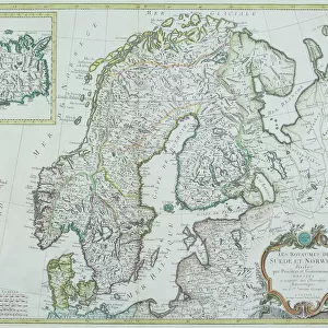
1794 Laurie And Whittle Map Of Norway Sweden

![]()
Wall Art and Photo Gifts from Universal Images Group (UIG)
1794 Laurie And Whittle Map Of Norway Sweden
1794, Laurie and Whittle Map of Norway, Sweden, Denmark and Finland, 1794 - 1812
Universal Images Group (UIG) manages distribution for many leading specialist agencies worldwide
Media ID 38548283
© Artokoloro Quint Lox Limited
1794 Sweden 1794 1812 Antique Map Latitude Longitude Mappa Mundi Old Antique Plan Old Antique View Ols Antique Map Rare Old Maps Topo
FEATURES IN THESE COLLECTIONS
> Europe
> Denmark
> Related Images
> Europe
> Finland
> Related Images
> Europe
> France
> Canton
> Landes
> Europe
> Norway
> Related Images
> Europe
> Sweden
> Related Images
> Historic
> Space exploration
> Universal Images Group (UIG)
> History
> Historical Maps
EDITORS COMMENTS
Step back in time to the late 18th century with this stunning print of Laurie and Whittle's 1794 map of Norway, Sweden, Denmark, and Finland. This beautifully rendered illustration is a testament to the cartographic skills of its creators, showcasing the geographical boundaries and topographical features of these Scandinavian countries with remarkable accuracy.
The intricate details on this vintage map are a treasure trove for history buffs and geography enthusiasts alike. From the winding coastlines to the mountainous landscapes, every aspect of these regions is meticulously depicted. The use of color adds an extra layer of depth and visual interest, making it easy to imagine oneself navigating through these territories during a bygone era.
This historic map is not only a fascinating piece of art but also a valuable resource for anyone interested in understanding the evolution of cartography over time. It serves as a reminder that even centuries ago, humans were driven to explore and document their surroundings, laying the groundwork for future generations.
Whether you're an avid collector or simply appreciate beautiful illustrations, this print is sure to captivate your imagination. Hang it proudly in your home or office as a conversation starter that sparks curiosity about our shared human desire for discovery.
MADE IN THE USA
Safe Shipping with 30 Day Money Back Guarantee
FREE PERSONALISATION*
We are proud to offer a range of customisation features including Personalised Captions, Color Filters and Picture Zoom Tools
SECURE PAYMENTS
We happily accept a wide range of payment options so you can pay for the things you need in the way that is most convenient for you
* Options may vary by product and licensing agreement. Zoomed Pictures can be adjusted in the Cart.