Home > Europe > France > Canton > Landes
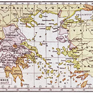
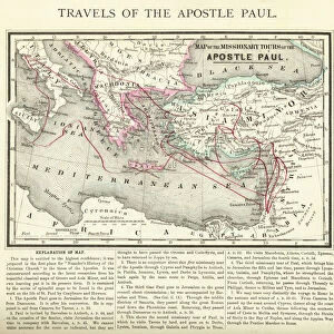
1794 Delisle Map Of Northern Ancient Greece Balkans

![]()
Wall Art and Photo Gifts from Universal Images Group (UIG)
1794 Delisle Map Of Northern Ancient Greece Balkans
1794, Delisle Map of Northern Ancient Greece, Balkans, Macedonia
Universal Images Group (UIG) manages distribution for many leading specialist agencies worldwide
Media ID 38548261
© Artokoloro Quint Lox Limited
1794 Balkans Macedonia Antique Map Latitude Longitude Mappa Mundi Old Antique Plan Old Antique View Ols Antique Map Rare Old Maps Topo
FEATURES IN THESE COLLECTIONS
> Europe
> France
> Canton
> Landes
> Europe
> Greece
> Related Images
> Europe
> Macedonia
> Related Images
> Historic
> Ancient civilizations
> Ancient Greece
> Greek history
> Historic
> Space exploration
> Maps and Charts
> Early Maps
> Maps and Charts
> North Macedonia
> Universal Images Group (UIG)
> History
> Historical Maps
EDITORS COMMENTS
Step back in time to the 18th century with this stunning print of the 1794 Delisle Map of Northern Ancient Greece and Balkans. Created by French cartographer Guillaume Delisle, this intricate map showcases the region's topography, geography, and landmarks with remarkable detail.
The map is a testament to Delisle's skill as a cartographer, featuring precise illustrations of mountains, rivers, and cities. The level of accuracy is impressive, considering the limited knowledge of the region at that time. From ancient ruins to modern settlements, every feature is meticulously rendered on this vintage map.
This print would make a unique addition to any room or office space. It's a beautiful piece of art that combines history and geography in one striking image. Perfect for anyone who loves maps, travel, or ancient civilizations.
The 1794 Delisle Map of Northern Ancient Greece and Balkans is not only a fascinating historical artifact but also an impressive work of art. Its aged look adds character and charm to any setting. Whether you're an historian or simply someone who appreciates beauty in design, this print is sure to captivate.
MADE IN THE USA
Safe Shipping with 30 Day Money Back Guarantee
FREE PERSONALISATION*
We are proud to offer a range of customisation features including Personalised Captions, Color Filters and Picture Zoom Tools
SECURE PAYMENTS
We happily accept a wide range of payment options so you can pay for the things you need in the way that is most convenient for you
* Options may vary by product and licensing agreement. Zoomed Pictures can be adjusted in the Cart.