Home > Europe > France > Canton > Landes
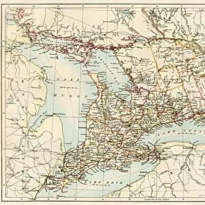
1778 Sartine Map Of Georgia North Carolina South Carolina

![]()
Wall Art and Photo Gifts from Universal Images Group (UIG)
1778 Sartine Map Of Georgia North Carolina South Carolina
1778, Sartine Map of Georgia, North Carolina, South Carolina, Virginia and Maryland
Universal Images Group (UIG) manages distribution for many leading specialist agencies worldwide
Media ID 38548153
© Artokoloro Quint Lox Limited
1778 North Carolina South Carolina Antique Map Latitude Longitude Mappa Mundi Old Antique Plan Old Antique View Ols Antique Map Rare Old Maps Topo
FEATURES IN THESE COLLECTIONS
> Asia
> Georgia
> Related Images
> Europe
> France
> Canton
> Landes
> Historic
> Space exploration
> Maps and Charts
> Early Maps
> Maps and Charts
> Related Images
> Maps and Charts
> World
> Universal Images Group (UIG)
> History
> Historical Maps
EDITORS COMMENTS
Step back in time to the late 18th century with this stunning print of the Sartine Map of Georgia, North Carolina, South Carolina, Virginia, and Maryland (1778). This beautifully rendered map is a testament to the cartographic skills of French cartographer Philippe Buache and his student Jean-Baptiste Bourguignon d'Anville. The intricate details and ornate illustrations on this vintage map showcase the geographical knowledge of the era.
The Sartine Map is a remarkable example of early American cartography, providing valuable insights into the region's topography, geography, and settlement patterns during a pivotal moment in American history. From the Blue Ridge Mountains to the Atlantic coastlines, every detail is meticulously drawn by hand using traditional techniques.
This rare and historic map has been carefully preserved for centuries, offering a unique glimpse into our collective past. Its beauty lies not only in its historical significance but also in its artistic value as an illustration piece. Whether you're an historian, geographer or simply someone fascinated by ancient maps, this print will transport you back to a time when exploration was at its peak.
Hang it proudly on your wall as a conversation starter or use it as inspiration for your next adventure - either way, this beautiful piece will be treasured for generations to come.
MADE IN THE USA
Safe Shipping with 30 Day Money Back Guarantee
FREE PERSONALISATION*
We are proud to offer a range of customisation features including Personalised Captions, Color Filters and Picture Zoom Tools
SECURE PAYMENTS
We happily accept a wide range of payment options so you can pay for the things you need in the way that is most convenient for you
* Options may vary by product and licensing agreement. Zoomed Pictures can be adjusted in the Cart.