Home > Europe > France > Canton > Landes
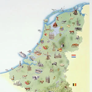
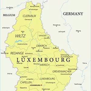
1771 Janvier Map Of Belgium And Luxembourg Topography

![]()
Wall Art and Photo Gifts from Universal Images Group (UIG)
1771 Janvier Map Of Belgium And Luxembourg Topography
1771, Janvier Map of Belgium and Luxembourg
Universal Images Group (UIG) manages distribution for many leading specialist agencies worldwide
Media ID 38550338
© Artokoloro Quint Lox Limited
1771 Antique Map Latitude Longitude Mappa Mundi Old Antique Plan Old Antique View Ols Antique Map Rare Old Maps Topo
FEATURES IN THESE COLLECTIONS
> Europe
> Belgium
> Related Images
> Europe
> France
> Canton
> Landes
> Europe
> Luxembourg
> Maps
> Europe
> Luxembourg
> Related Images
> Historic
> Space exploration
> Maps and Charts
> Early Maps
> Maps and Charts
> Luxembourg
> Maps and Charts
> Related Images
> Universal Images Group (UIG)
> History
> Historical Maps
EDITORS COMMENTS
Step back in time and explore the fascinating topography of Belgium and Luxembourg with this stunning 18th-century map. Created by French cartographer Jean-Baptiste Janvier in 1771, this vintage print is a remarkable example of early modern cartography. The intricate illustration depicts the region's geographical features, including mountains, rivers, and cities, with meticulous attention to detail.
The map showcases the region's complex network of borders, roads, and waterways, providing a unique glimpse into the historical landscape of Europe during the late 18th century. From the rolling hills of Luxembourg to the fertile plains of Flanders, every aspect of this beautiful region is meticulously rendered on paper.
This historic map is not only a testament to Janvier's skill as a cartographer but also a window into the past for anyone interested in geography, history, or travel. Imagine being able to navigate these lands just as explorers did centuries ago! This rare and exquisite print would make an extraordinary addition to any collection or study dedicated to cartography or European history.
MADE IN THE USA
Safe Shipping with 30 Day Money Back Guarantee
FREE PERSONALISATION*
We are proud to offer a range of customisation features including Personalised Captions, Color Filters and Picture Zoom Tools
SECURE PAYMENTS
We happily accept a wide range of payment options so you can pay for the things you need in the way that is most convenient for you
* Options may vary by product and licensing agreement. Zoomed Pictures can be adjusted in the Cart.