Home > Europe > France > Canton > Landes
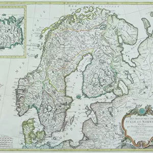
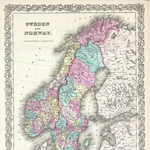
1747 La Feuille Map Of Scandinavia Sweden Norway

![]()
Wall Art and Photo Gifts from Universal Images Group (UIG)
1747 La Feuille Map Of Scandinavia Sweden Norway
1747, La Feuille Map of Scandinavia, Sweden, Norway, Finland
Universal Images Group (UIG) manages distribution for many leading specialist agencies worldwide
Media ID 38547939
© Artokoloro Quint Lox Limited
1747 Finland Norway Sweden Antique Map Latitude Longitude Mappa Mundi Old Antique Plan Old Antique View Ols Antique Map Rare Old Maps Topo
FEATURES IN THESE COLLECTIONS
> Europe
> Finland
> Related Images
> Europe
> France
> Canton
> Landes
> Europe
> Norway
> Related Images
> Europe
> Sweden
> Related Images
> Historic
> Space exploration
> Maps and Charts
> Early Maps
> Universal Images Group (UIG)
> History
> Historical Maps
EDITORS COMMENTS
Step back in time to the 18th century with this stunning print of the 1747 La Feuille Map of Scandinavia, Sweden, Norway, and Finland. This beautifully rendered map is a testament to the cartographic skills of its creator, showcasing the region's topography with intricate detail and precision.
The map features a striking illustration of the Scandinavian peninsula, including Sweden and Norway's rugged coastlines, mountains, and forests. The bordering countries of Finland are also depicted with remarkable accuracy. The terrain is marked by varying shades of color, giving a sense of depth and dimensionality to the landscape.
This vintage map is not only a fascinating piece of historical geography but also an artistic masterpiece. The ornate borders and decorative elements add an air of elegance to the overall design. It's easy to imagine this map being used by explorers or travelers planning their journeys through these vast lands.
As you gaze upon this antique treasure, you're transported back in time to an era when navigation relied on maps like this one. Take a moment to appreciate the craftsmanship that went into creating such a beautiful representation of our world.
MADE IN THE USA
Safe Shipping with 30 Day Money Back Guarantee
FREE PERSONALISATION*
We are proud to offer a range of customisation features including Personalised Captions, Color Filters and Picture Zoom Tools
SECURE PAYMENTS
We happily accept a wide range of payment options so you can pay for the things you need in the way that is most convenient for you
* Options may vary by product and licensing agreement. Zoomed Pictures can be adjusted in the Cart.