Home > Europe > France > Canton > Landes
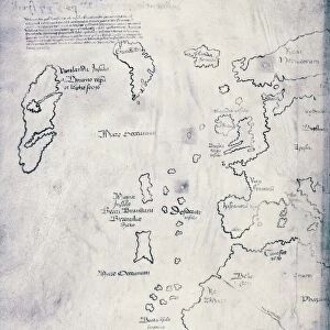
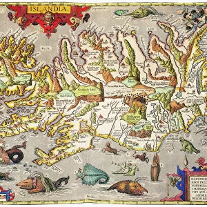
1747 Bowen Map Of The North Atlantic Islands

![]()
Wall Art and Photo Gifts from Universal Images Group (UIG)
1747 Bowen Map Of The North Atlantic Islands
1747, Bowen Map of the North Atlantic Islands, Greenland, Iceland, Faroe Islands, Maelstrom
Universal Images Group (UIG) manages distribution for many leading specialist agencies worldwide
Media ID 38547925
© Artokoloro Quint Lox Limited
1747 Greenland Iceland Antique Map Faroe Islands Latitude Longitude Maelstrom Mappa Mundi Old Antique Plan Old Antique View Ols Antique Map Rare Old Maps Topo
FEATURES IN THESE COLLECTIONS
> Europe
> France
> Canton
> Landes
> Europe
> Iceland
> Related Images
> Historic
> Space exploration
> Maps and Charts
> Early Maps
> Maps and Charts
> Related Images
> Maps and Charts
> World
> North America
> Greenland
> Maps
> North America
> Greenland
> Related Images
> Universal Images Group (UIG)
> History
> Historical Maps
EDITORS COMMENTS
Step back in time to the 18th century with this stunning print of the Bowen Map of the North Atlantic Islands, created in 1747. This beautifully detailed illustration depicts the islands of Greenland, Iceland, and the Faroe Islands, showcasing their rugged landscapes and intricate coastlines. The map also highlights the treacherous waters known as Maelstrom, a notorious whirlpool that has claimed many ships throughout history.
This vintage map is a testament to the cartographic skills of its creator, Emanuel Bowen, who was one of the most renowned cartographers of his time. His meticulous attention to detail and use of vibrant colors bring this region to life on paper. The map's geometric layout and grid system provide a sense of order amidst the vast expanse of ocean and land.
This historic print is not only a beautiful piece of art but also a valuable resource for anyone interested in geography, topography, or maritime history. It would be an excellent addition to any collection or office decor that celebrates exploration and discovery. So why not take a journey through time with this remarkable map from 1747?
MADE IN THE USA
Safe Shipping with 30 Day Money Back Guarantee
FREE PERSONALISATION*
We are proud to offer a range of customisation features including Personalised Captions, Color Filters and Picture Zoom Tools
SECURE PAYMENTS
We happily accept a wide range of payment options so you can pay for the things you need in the way that is most convenient for you
* Options may vary by product and licensing agreement. Zoomed Pictures can be adjusted in the Cart.