Home > Europe > France > Canton > Landes
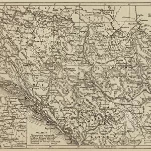
1690 Coronelli Map Of Montenegro Topography Cartography

![]()
Wall Art and Photo Gifts from Universal Images Group (UIG)
1690 Coronelli Map Of Montenegro Topography Cartography
1690, Coronelli Map of Montenegro
Universal Images Group (UIG) manages distribution for many leading specialist agencies worldwide
Media ID 38550136
© Artokoloro Quint Lox Limited
1690 Antique Map Latitude Longitude Mappa Mundi Old Antique Plan Old Antique View Ols Antique Map Rare Old Maps Topo
FEATURES IN THESE COLLECTIONS
> Europe
> France
> Canton
> Landes
> Europe
> Montenegro
> Maps
> Europe
> Montenegro
> Related Images
> Historic
> Space exploration
> Maps and Charts
> Early Maps
> Maps and Charts
> Montenegro
> Maps and Charts
> Related Images
> Maps and Charts
> World
> Universal Images Group (UIG)
> History
> Historical Maps
EDITORS COMMENTS
Step back in time and explore the breathtaking topography of Montenegro with this stunning 1690 Coronelli map. Created by Italian cartographer Vincenzo Coronelli, this vintage illustration showcases the region's intricate geography, featuring mountains, rivers, and valleys in exquisite detail. The map is a testament to the art of cartography during the 17th century, when explorers and mapmakers were pushing the boundaries of knowledge about our world.
This historic print offers a unique glimpse into the past, revealing how our understanding of geography has evolved over time. The Coronelli map is a masterpiece of its era, showcasing meticulous attention to detail and artistic flair. From the rugged peaks of Mount Lovćen to the tranquil waters of Lake Skadar, every feature is meticulously rendered in precise lines and elegant script.
As you gaze upon this ancient chart, imagine yourself on a journey through time, tracing the routes taken by travelers and traders who once traversed these lands. This beautiful piece would make a captivating addition to any collection or room decor, serving as a reminder of humanity's enduring fascination with exploration and discovery.
MADE IN THE USA
Safe Shipping with 30 Day Money Back Guarantee
FREE PERSONALISATION*
We are proud to offer a range of customisation features including Personalised Captions, Color Filters and Picture Zoom Tools
SECURE PAYMENTS
We happily accept a wide range of payment options so you can pay for the things you need in the way that is most convenient for you
* Options may vary by product and licensing agreement. Zoomed Pictures can be adjusted in the Cart.