Fraud Blocker Skip to main content

Home > Maps and Charts > Germany

Germany Collection (#4)

Germany is a country located in central Europe with a population of over 83 million people and has a diverse landscape

6,586 Items

Background imageGermany Collection: Brazil & Bras Portrait

Brazil & Bras Portrait
A map of Brazil with a portrait of its then president Venceslau Bras. Brazil had declared war on Germany in 1917 during World War One

Background imageGermany Collection: World map Universalis Cosmographia, 1507. Artist: Waldseemuller, Martin (ca 1472-1520)

World map Universalis Cosmographia, 1507. Artist: Waldseemuller, Martin (ca 1472-1520)
World map Universalis Cosmographia, 1507. Found in the collection of the Library of Congress, Washington D. C

Background imageGermany Collection: Franco-Prussian War: Map of Alsace and Lorraine, Counties Given to the German Empire 1870

Franco-Prussian War: Map of Alsace and Lorraine, Counties Given to the German Empire 1870

Background imageGermany Collection: Map of Germany, 1819, J. Mawman

Map of Germany, 1819, J. Mawman

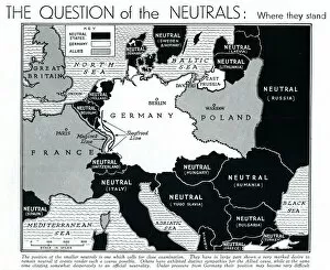
Background imageGermany Collection: Map of Europe showing WW2 alliances, September 1939

Map of Europe showing WW2 alliances, September 1939
A map of Europe, colour-coded to represent the different alliances between nations shortly after the outbreak of war, September 1939

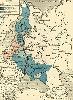
Background imageGermany Collection: Map illustrating the Brest-Litovsk Treaties, First World War, c1918, (c1920). Creator: Unknown

Map illustrating the Brest-Litovsk Treaties, First World War, c1918, (c1920). Creator: Unknown
Map illustrating the Brest-Litovsk Treaties, First World War, c1918, (c1920). Pink: Areas taken by Germany ; dark blue: Nationalities of self-determination ; light blue

Background imageGermany Collection: Australia Map Gotha, Justus Perthes, 1872, Atlas

Australia Map Gotha, Justus Perthes, 1872, Atlas. Perthes, Johan Georg Justus 1749 aa 1816, German publisher, was born in Rudolstadt in 1749

Background imageGermany Collection: Illustration shows stinkhorn mushrooms. Basimycetes

Illustration shows stinkhorn mushrooms. Basimycetes. - Schwammpilze, 1 print : photomechanical; sheet 36 x 26 cm. 1904. Ernst Haeckel 1834 a 1919 German biologist, naturalist, philosopher, physician

Background imageGermany Collection: Munich Map

Munich Map
Jazzberry Blue

Background imageGermany Collection: 8934464

8934464

Background imageGermany Collection: 8937516

8937516

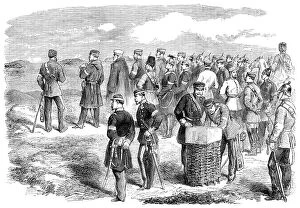
Background imageGermany Collection: The War in Denmark: Prince Frederick Charles and staff directing the assault on Düppel..., 1864

The War in Denmark: Prince Frederick Charles and staff directing the assault on Düppel..., 1864. Creator: Unknown
The War in Denmark: Prince Frederick Charles and staff directing the assault on Duppel - from a sketch by our special artist, 1864

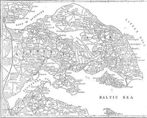
Background imageGermany Collection: The seat of war in Denmark, 1864. Creator: Unknown

The seat of war in Denmark, 1864. Creator: Unknown
The seat of war in Denmark, 1864. 'The Map gives a correct outline of the Sundewitt Peninsula, including the fortified lines of Duppel on the nose of land between Als Sund (the Alsen Strait)

Background imageGermany Collection: Pair of maps of the Northern and Southern Celestial Hemispheres, 17th century (engraving)

Pair of maps of the Northern and Southern Celestial Hemispheres, 17th century (engraving)
7337557 Pair of maps of the Northern and Southern Celestial Hemispheres, 17th century (engraving) by Durer or Duerer, Albrecht (1471-1528); National Maritime Museum, London

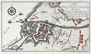
Background imageGermany Collection: Plan of Memel (present-day Klaipeda, Lithuania), during the surrender of the city

Plan of Memel (present-day Klaipeda, Lithuania), during the surrender of the city, 27 June to 5 July 1757
MMM5482024 Plan of Memel (present-day Klaipeda, Lithuania), during the surrender of the city, 27 June to 5 July 1757. Etching water in 1764 colors.; National Maritime Museum, London

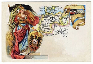
Background imageGermany Collection: Allegory of German Unity 1871 (Germany and Prussia reunited): The Reich 1871

Allegory of German Unity 1871 (Germany and Prussia reunited): The Reich 1871
FGL5479410 Allegory of German Unity 1871 (Germany and Prussia reunited): The Reich 1871. Sadowa's victory on 03/07/1866, won by the Prussians over the Austrians

Background imageGermany Collection: Vellum chart of Africa, India and the Mediterranean, 1554 (vellum)

Vellum chart of Africa, India and the Mediterranean, 1554 (vellum)
7339652 Vellum chart of Africa, India and the Mediterranean, 1554 (vellum) by Agnese, Battista (c.1500-64); 26x40 cm; National Maritime Museum, London

Background imageGermany Collection: Map of Das Heilige Land 1554 [Translation: The Holy land], 1554 (vellum)

Map of Das Heilige Land 1554 [Translation: The Holy land], 1554 (vellum)
7339649 Map of Das Heilige Land 1554 [Translation: The Holy land], 1554 (vellum) by Agnese, Battista (c.1500-64); 26x40 cm; National Maritime Museum, London

Background imageGermany Collection: Map of Creta 1554, 1554 (vellum)

Map of Creta 1554, 1554 (vellum)
7339647 Map of Creta 1554, 1554 (vellum) by Agnese, Battista (c.1500-64); 26x40 cm; National Maritime Museum, London, UK; (add.info.: Creator: Battista Agnese Bound sheet. Scale: [circa 1:3 000 000])

Background imageGermany Collection: Chart of Chius (Chios, Greece), 1554 (vellum)

Chart of Chius (Chios, Greece), 1554 (vellum)
7339646 Chart of Chius (Chios, Greece), 1554 (vellum) by Agnese, Battista (c.1500-64); 26x40 cm; National Maritime Museum, London, UK; (add.info.: Creator: Battista Agnese Scale circa 1:650000)

Background imageGermany Collection: Map of nerve bundles in the human brain by Paul Broca

Map of nerve bundles in the human brain by Paul Broca
5309460 Map of nerve bundles in the human brain by Paul Broca; (add.info.: Map of nerve bundles in the human brain by Paul Broca)

Background imageGermany Collection: Map showing the placings in Australia of The Tolpuddle Martyrs

Map showing the placings in Australia of The Tolpuddle Martyrs, a group of 19th-century Dorset agricultural labourers
5614433 Map showing the placings in Australia of The Tolpuddle Martyrs, a group of 19th-century Dorset agricultural labourers who were arrested for

Background imageGermany Collection: Map of Abyssinia (Ethiopia), 19th century (map)

Map of Abyssinia (Ethiopia), 19th century (map)
6317642 Map of Abyssinia (Ethiopia), 19th century (map); (add.info.: Map of Abyssinia and the Adjacent Districts. From observations taken by British traveller and artist Henry Salt in 1809 and 1810)

Background imageGermany Collection: Map of the Suez Canal (litho)

Map of the Suez Canal (litho)
8663893 Map of the Suez Canal (litho) by German School, (20th century); Private Collection; (add.info.: Map of the Suez Canal, Egypt)

Background imageGermany Collection: Kiel Canal, Germany (litho)

Kiel Canal, Germany (litho)
8663891 Kiel Canal, Germany (litho) by German School, (20th century); Private Collection; (add.info.: Map showing the route of the Kiel Canal connecting the North Sea to the Baltic, Germany)

Background imageGermany Collection: Port of Hamburg (litho)

Port of Hamburg (litho)
8663890 Port of Hamburg (litho) by German School, (20th century); Private Collection; (add.info.: Port of Hamburg, Germany)

Background imageGermany Collection: Major international telegraph cables (colour litho)

Major international telegraph cables (colour litho)
8663671 Major international telegraph cables (colour litho) by German School, (20th century); Private Collection; (add.info)

Background imageGermany Collection: Germany in the time of the Romans (colour litho)

Germany in the time of the Romans (colour litho)
8672805 Germany in the time of the Romans (colour litho) by German School, (20th century); Private Collection; (add.info.: Map of Germany in the time of the Romans)

Background imageGermany Collection: United States, South Carolina: Colonial Map of the Ashley and Cooper Rivers, Charleston Site

United States, South Carolina: Colonial Map of the Ashley and Cooper Rivers, Charleston Site, South Carolina
NWI4967326 United States, South Carolina: Colonial Map of the Ashley and Cooper Rivers, Charleston Site, South Carolina, 17th century

Background imageGermany Collection: Map of Boston (Massachusetts, USA), with British forces retreats, in 1775

Map of Boston (Massachusetts, USA), with British forces retreats, in 1775
NWI4843670 Map of Boston (Massachusetts, USA), with British forces retreats, in 1775. (War of Independence of the United States, 1776-1783)

Background imageGermany Collection: Map of Scotland, England, Ireland in 1100 (Map of british islands, England)

Map of Scotland, England, Ireland in 1100 (Map of british islands, England)
ELD4930022 Map of Scotland, England, Ireland in 1100 (Map of british islands, England, Scotland and Ireland in 1100) Plate from Houze's Universal Atlas

Background imageGermany Collection: map of ' Hamburg and the surrounding in the year 1240, 1866 (engraving)

map of " Hamburg and the surrounding in the year 1240, 1866 (engraving)
UTD4918756 map of " Hamburg and the surrounding in the year 1240, 1866 (engraving); (add.info.: Germany, Hamburg, map " Hamburg and the surrounding in the year 1240 ")

Background imageGermany Collection: Geographic map of Germany populated with different populations before 275 BC (Map of Germania)

Geographic map of Germany populated with different populations before 275 BC (Map of Germania)
ELD4924495 Geographic map of Germany populated with different populations before 275 BC (Map of Germania, inhabited by different tribes)

Background imageGermany Collection: Map of the Count of Sommerset (England), circa 1870. 19th century lithography

Map of the Count of Sommerset (England), circa 1870. 19th century lithography
NWI4875372 Map of the Count of Sommerset (England), circa 1870. 19th century lithography.; (add.info.: Map of the Count of Sommerset (England), circa 1870

Background imageGermany Collection: Map of the Counts of Oxford, Buckingham and Berks (England), circa 1870. 19th century lithography

Map of the Counts of Oxford, Buckingham and Berks (England), circa 1870. 19th century lithography
NWI4875323 Map of the Counts of Oxford, Buckingham and Berks (England), circa 1870. 19th century lithography.; (add.info.: Map of the Counts of Oxford, Buckingham and Berks (England), circa 1870

Background imageGermany Collection: Map of the Earl of Worcester (England), circa 1870. 19th century lithography

Map of the Earl of Worcester (England), circa 1870. 19th century lithography
NWI4875595 Map of the Earl of Worcester (England), circa 1870. 19th century lithography.; (add.info.: Map of the Earl of Worcester (England), circa 1870

Background imageGermany Collection: Map of the Earl of Sussex (England), circa 1870. 19th century lithography

Map of the Earl of Sussex (England), circa 1870. 19th century lithography
NWI4875444 Map of the Earl of Sussex (England), circa 1870. 19th century lithography.; (add.info.: Map of the Earl of Sussex (England), circa 1870

Background imageGermany Collection: Map of the Earl of Yorkshire (England), circa 1870. 19th century lithography

Map of the Earl of Yorkshire (England), circa 1870. 19th century lithography
NWI4875608 Map of the Earl of Yorkshire (England), circa 1870. 19th century lithography.; (add.info.: Map of the Earl of Yorkshire (England), circa 1870

Background imageGermany Collection: Map of the German Empire (Germany), late 19th century - Lithograph 19th century - Map of

Map of the German Empire (Germany), late 19th century - Lithograph 19th century - Map of the German Empire
NWI4872372 Map of the German Empire (Germany), late 19th century - Lithograph 19th century - Map of the German Empire, late 1800s - Color lithograph; (add.info.: Map of the German Empire (Germany)

Background imageGermany Collection: Map showing Louisbourg, a Canadian city in the province of Nova Scotia, Canada

Map showing Louisbourg, a Canadian city in the province of Nova Scotia, Canada, under the British flag, 1745
NWI4867370 Map showing Louisbourg, a Canadian city in the province of Nova Scotia, Canada, under the British flag, 1745. Colouring engraving of the 19th century.; (add.info.: Map showing Louisbourg)

Background imageGermany Collection: Map of the Kingdom of Prussia, 1866. Detail of the principal of Hohenzollern

Map of the Kingdom of Prussia, 1866. Detail of the principal of Hohenzollern. 19th century lithography
NWI4871529 Map of the Kingdom of Prussia, 1866. Detail of the principal of Hohenzollern. 19th century lithography.; (add.info.: Map of the Kingdom of Prussia, 1866)

Background imageGermany Collection: King Charlemagne (742-814) studying the plans for the construction of the palatine chapel in

King Charlemagne (742-814) studying the plans for the construction of the palatine chapel in Aachen submitted by his
ELD4931510 King Charlemagne (742-814) studying the plans for the construction of the palatine chapel in Aachen submitted by his advisor Alcuin (731-804)

Background imageGermany Collection: Illustration of the book by Leo Taxil and J. Vindex 'Marat ou les heros de la revolution'

Illustration of the book by Leo Taxil and J. Vindex "Marat ou les heros de la revolution"
PCT4285584 Illustration of the book by Leo Taxil and J. Vindex "Marat ou les heros de la revolution", Librairie anti-clerical (anti-clerical, anticlerical) 1883 - Revolution Francaise

Background imageGermany Collection: First World War: Patriotic Map of France Inducing French Soldiers to Charge Sword in the Clear, 1915

First World War: Patriotic Map of France Inducing French Soldiers to Charge Sword in the Clear, 1915
LUX4744882 First World War: Patriotic Map of France Inducing French Soldiers to Charge Sword in the Clear, 1915; (add.info.: First World War - War 14-18 (1914-1918) - World War I (WWI or WW1)

Background imageGermany Collection: First World War: France, Patriotic Map showing a caricature of an ugly and fat German woman, 1916

First World War: France, Patriotic Map showing a caricature of an ugly and fat German woman, 1916
LUX4741828 First World War: France, Patriotic Map showing a caricature of an ugly and fat German woman, 1916, Map titled: Berlin elegance; (add.info)

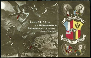
Background imageGermany Collection: First World War: France, Patriotic Map showing a copy of a painting by Prud'hon entitled

First World War: France, Patriotic Map showing a copy of a painting by Prud'hon entitled
LUX4740947 First World War: France, Patriotic Map showing a copy of a painting by Prud'hon entitled: Justice and revenge pursuing the crime represented here by William II with the portrait of

Background imageGermany Collection: Patriotic map showing France heating water in a German helmet and strangling the enemy eagle

Patriotic map showing France heating water in a German helmet and strangling the enemy eagle
LUX4743661 Patriotic map showing France heating water in a German helmet and strangling the enemy eagle and titled "L'Aigle wesse"

Background imageGermany Collection: First World War: Patriotic map showing a soldier facing the German artillery declaring

First World War: Patriotic map showing a soldier facing the German artillery declaring: Throw fury today, Germain
LUX4744300 First World War: Patriotic map showing a soldier facing the German artillery declaring: Throw fury today, Germain, we shall be victor tomorrow


All Professionally Made to Order for Quick Shipping


-

Germany Collection

Germany is a country located in central Europe with a population of over 83 million people and has a diverse landscape, ranging from the Alps in the south to the North Sea and Baltic Sea coasts in the north. The country is known for its strong economy, which is driven by industries such as automotive manufacturing, engineering, and pharmaceuticals. It also has a rich cultural history, with famous composers like Beethoven and Bach hailing from the country. Its capital city Berlin is renowned for its vibrant art scene and historical landmarks such as the Brandenburg Gate.
+

Our beautiful Wall Art and Photo Gifts include Framed Prints, Photo Prints, Poster Prints, Canvas Prints, Jigsaw Puzzles, Metal Prints and so much more

The Germany collection from Media Storehouse offers a wide selection of wall art and framed prints that showcase the beauty, history, and culture of Germany. Our collection features an array of maps and charts that depict the country's geography, landmarks, cities, regions, and historical events. From vintage maps to modern designs, our collection caters to different tastes and preferences. Some of the popular items in our collection include antique city plans of Berlin or Munich; topographic maps of Bavaria or Black Forest; political maps showing Germany's borders over time; charts illustrating Germanic tribes' migration patterns during ancient times. These artworks are available in various sizes and formats such as canvas prints or traditional frames. They make great decorations for homes, offices or public spaces like museums or libraries. The Germany collection is a must-see for anyone interested in exploring the rich heritage of this fascinating country through visual art.
+

What are Germany (Maps and Charts) art prints?

Germany art prints are high-quality reproductions of historical maps and charts depicting various regions, cities, and landmarks in Germany. These prints showcase the intricate details of the original maps and charts, including topography, street names, buildings, rivers, and other geographical features. These art prints are perfect for history enthusiasts who want to explore Germany's rich cultural heritage or for those who simply appreciate beautiful cartographic artwork. They can be used as decorative pieces in homes or offices or as educational tools in schools and libraries. We offer a wide range of Germany art prints that cater to different tastes and preferences. You can choose from vintage-style sepia-toned maps to colorful contemporary designs that highlight specific areas or themes such as wine regions or cycling routes. These art prints provide a unique way to experience Germany's geography and history while adding aesthetic value to any space.
+

What Germany (Maps and Charts) art prints can I buy from Media Storehouse?

We offer a wide range of Germany maps and charts art prints that you can purchase. These include vintage maps, city plans, topographical charts, and historical atlases. You can choose from different styles and sizes to suit your preferences. One popular option is the antique map of Germany created by cartographer Gerard Mercator in 1595. This beautifully detailed map shows the country's regions, cities, rivers, and mountains as they were known during the Renaissance period. Another interesting print is the Berlin Wall Map which depicts the infamous wall that divided East and West Berlin during the Cold War era. The map includes details on checkpoints, watchtowers, escape tunnels and other features related to this historic event. Whether you are looking for a decorative piece for your home or office or an educational resource for teaching purposes, we have a variety of Germany maps and charts art prints available to suit your needs.
+

How do I buy Germany (Maps and Charts) art prints?

To buy Germany art prints from Media Storehouse, you can browse our extensive collection of high-quality prints online. Simply search for the specific artwork or artist you are interested in, or filter by category to find maps and charts related to Germany. Once you have found a print that catches your eye, select the size and format that best suits your needs. We offer a range of options for printing on different materials such as canvas, photographic paper, and fine art paper. You can also choose to have your print framed or unframed depending on your preference. Once you have made your selection, simply add it to your cart and proceed to checkout. Payment is easy with various payment methods available including credit card payments. Buying Germany art prints from Media Storehouse is a straightforward process that allows you to easily access beautiful artworks at affordable prices.
+

How much do Germany (Maps and Charts) art prints cost?

We offer a wide range of Germany art prints at varying prices. Our collection includes vintage maps, historical charts, and modern interpretations of the country's geography. The cost of each print depends on several factors such as size, framing options, and printing material. We understand that every customer has unique preferences when it comes to purchasing art prints. That is why we have made sure to provide a diverse selection that caters to different tastes and budgets. Whether you are looking for an affordable poster or a high-quality canvas print, we have something for everyone. Our Germany art prints make great additions to any home or office space. They are not only aesthetically pleasing but also educational pieces that can spark interesting conversations about history and geography. So if you're interested in adding some German-inspired artwork to your collection, be sure to check out our selection today.
+

How will my Germany (Maps and Charts) art prints be delivered to me?

Your Germany art prints will be delivered to you in a safe and secure manner by our trusted delivery partners. We take great care to ensure that your artwork is packaged with the utmost care, so it arrives at your doorstep in pristine condition. Depending on the size of your order, we may use different shipping methods such as standard post or courier services. We understand how important it is for you to receive your artwork promptly, which is why we work hard to dispatch all orders as quickly as possible. Once dispatched, you will receive an email notification containing tracking information so that you can keep track of your package's progress. We are committed to providing our customers with high-quality products and exceptional service. If for any reason you are not completely satisfied with your purchase, please do not hesitate to contact us so that we can resolve any issues promptly.