Home > Arts > Artists > W > Henry Walter
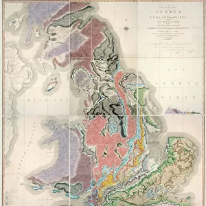
Upper Nile Basin Map; The regions of the Cazembe, 1875. Creator: Charles Tilstone Beke

![]()
Wall Art and Photo Gifts from Heritage Images
Upper Nile Basin Map; The regions of the Cazembe, 1875. Creator: Charles Tilstone Beke
Upper Nile Basin Map; The regions of the Cazembe, 1875. From, Illustrated Travels by H.W. Bates. [Cassell, Petter, and Galpin, c1880, London]
Heritage Images features heritage image collections
Media ID 36352495
© The Print Collector/Heritage Images
1870s Bates Henry Walter Bates Hw Cartography Cassell Petter Galpin East Africa East African Geological Map Henry Walter Bates Hw Bates Illustrated Travels Map Making Mapmaking Nile Petter And Galpin River Nile The Nile Cassell Nile Basin
FEATURES IN THESE COLLECTIONS
> Arts
> Artists
> W
> Charles White
> Arts
> Artists
> W
> Henry Walter
> Arts
> Literature
> Maps and Charts
> Geological Map
> Maps and Charts
> Related Images
EDITORS COMMENTS
This print, titled 'Upper Nile Basin Map; The regions of the Cazembe' by Charles Tilstone Beke, dates back to the 1870s and is taken from Henry Walter Bates' 'Illustrated Travels'. The map provides a detailed geographical representation of the Upper Nile Basin during the late 19th century, with a particular focus on the regions of Cazembe. Charles Tilstone Beke (1827-1894) was a British explorer, naturalist, and cartographer, who made significant contributions to the scientific understanding of Africa during the Victorian era. This map, produced in London by Cassell, Petter, and Galpin, reflects Beke's extensive knowledge of the region and his meticulous attention to detail. The map illustrates the Nile River and its tributaries, as well as various geological features and locations in East Africa. The Nile, the longest river in the world, is depicted flowing from Lake Victoria in the south to the Mediterranean Sea in the north. The map also highlights the regions of Cazembe, which were of particular interest to Beke due to their rich natural resources and cultural significance. The mapmaking process during this period was a complex and time-consuming endeavor, requiring extensive fieldwork, precise measurements, and intricate drafting techniques. Beke's 'Upper Nile Basin Map; The regions of the Cazembe' is a testament to the dedication and expertise of the cartographer and the advances in geographical knowledge during the 19th century. Today, this historical map remains an important resource for scholars and researchers studying the history of Africa, cartography, and the exploration of the Nile River. Its intricate details and historical significance make it a valuable addition to any collection of maps or Africana.
MADE IN THE USA
Safe Shipping with 30 Day Money Back Guarantee
FREE PERSONALISATION*
We are proud to offer a range of customisation features including Personalised Captions, Color Filters and Picture Zoom Tools
SECURE PAYMENTS
We happily accept a wide range of payment options so you can pay for the things you need in the way that is most convenient for you
* Options may vary by product and licensing agreement. Zoomed Pictures can be adjusted in the Cart.