Home > Arts > Artists > C > William Caxton
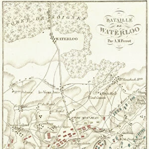
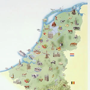
Map of the Belgian Frontier with Forts, 1919. Creator: Unknown

![]()
Wall Art and Photo Gifts from Heritage Images
Map of the Belgian Frontier with Forts, 1919. Creator: Unknown
Map of the Belgian Frontier with Forts, 1919. Map showing Belgium, Holland and parts of Germany and France during the First World War, 1914-1919. Fortified towns and principal railways are indicated. From " The History of the Great European War: its causes and effects", Vol. I, by W. Stanley Macbean Knight. [Caxton Pulishing Company, Limited, London, 1919]
Heritage Images features heritage image collections
Media ID 19047941
© The Print Collector/Heritage Images
Caxton Publishing Company Caxton Pulishing Company Caxton Pulishing Company Lim Caxton Pulishing Company Limited Caxton Pulishing Company Ltd Fort Forts Frontier Knight Limited Luxembourg North Sea Stanley Macbean Stanley Macbean Knight W Stanley Macbean W Stanley Macbean Knight William Stanley Macbean William Stanley Macbean Knight
FEATURES IN THESE COLLECTIONS
> Arts
> Artists
> C
> William Caxton
> Europe
> Belgium
> Related Images
> Europe
> Luxembourg
> Maps
> Europe
> Luxembourg
> Posters
EDITORS COMMENTS
This print showcases a detailed "Map of the Belgian Frontier with Forts, 1919". Created by an unknown artist, this map provides a glimpse into the complex geopolitical landscape of Europe during the First World War. Spanning Belgium, Holland, parts of Germany and France, it offers a comprehensive view of fortified towns and principal railways in the region. The historical significance of this map is further emphasized by its inclusion in W. Stanley Macbean Knight's renowned publication, "The History of the Great European War: its causes and effects". Volume I. Published by Caxton Publishing Company Ltd. in London in 1919, this book serves as a valuable resource for understanding the events that unfolded during this tumultuous period. With vibrant colors and intricate details, this print transports us back to an era marked by conflict and uncertainty. It highlights not only geographical features such as coastlines and borders but also emphasizes strategic fortifications along key points on the frontier. As we observe this image today, we are reminded of the immense impact that war had on nations across Europe during World War I. This photograph captures both the physical structures built for defense purposes and symbolizes how political boundaries were redrawn through military conquests. Preserved by The Print Collector from Heritage Images collection, this remarkable piece allows us to delve into history while appreciating both its artistic value and educational significance.
MADE IN THE USA
Safe Shipping with 30 Day Money Back Guarantee
FREE PERSONALISATION*
We are proud to offer a range of customisation features including Personalised Captions, Color Filters and Picture Zoom Tools
SECURE PAYMENTS
We happily accept a wide range of payment options so you can pay for the things you need in the way that is most convenient for you
* Options may vary by product and licensing agreement. Zoomed Pictures can be adjusted in the Cart.