Fraud Blocker Skip to main content

Countries Collection (#3)

"The King of Kings: A glimpse into the diverse tapestry throughout history" Daily Mail War Map, WW1: Unveiling the global impact of nations during the Great War

Background imageCountries Collection: Bled Island (Blejski otok) with the Church of the Assumption (Cerkev Marijinega vnebovzetja)

Bled Island (Blejski otok) with the Church of the Assumption (Cerkev Marijinega vnebovzetja) at sunset, Lake Bled, Bled, Upper Carniola, Julian Alps, Slovenia

Background imageCountries Collection: Map showing the territory (shaded dark) recaptured during the Russian winter offensive

Map showing the territory (shaded dark) recaptured during the Russian winter offensive
20th Century, Archival, Archive, Conflict, Countries, Country, December 1941, Engraving, Geographical, Geography, Historical, History, Illustration, May 1942, Offensive, Old, Period, Picture, Print

Background imageCountries Collection: 18th century map by Herman Moll showing, The West Part of Barbary Containing Fez

18th century map by Herman Moll showing, The West Part of Barbary Containing Fez, Marocco Algiers and Tunis - The East Part of Barbary containing Tripoli, Barca and the North Part of Egypt.

Background imageCountries Collection: 19th century map showing The World as peopled by The Descendants of Noah

19th century map showing The World as peopled by The Descendants of Noah.

Background imageCountries Collection: 19th century map showing the Journeyings of The Children of Israel from Egypt to the Land of Canaan

19th century map showing the Journeyings of The Children of Israel from Egypt to the Land of Canaan.

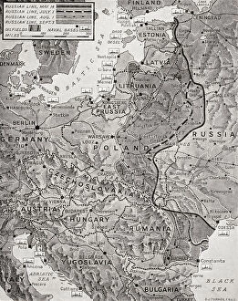
Background imageCountries Collection: Map showing the advance of the Russian Army in their effort to wipe out the enemy, August 1944

Map showing the advance of the Russian Army in their effort to wipe out the enemy, August 1944. From The War in Pictures, Fifth Year.

Background imageCountries Collection: Map of Afrique showing Possessions et protectorats d'Europe, 1914. Creator: Unknown

Map of Afrique showing Possessions et protectorats d'Europe, 1914. Creator: Unknown
Map of Afrique showing Possessions et protectorats d'Europe, 1914. From "Grande Geographie Bong Illustree", 1914

Background imageCountries Collection: City Love Maps 28

City Love Maps 28
Emiliano Deificus

Background imageCountries Collection: City Love Maps 23

City Love Maps 23
Emiliano Deificus

Background imageCountries Collection: City Love Maps 33

City Love Maps 33
Emiliano Deificus

Background imageCountries Collection: City Love Maps 29

City Love Maps 29
Emiliano Deificus

Background imageCountries Collection: City Love Maps 03

City Love Maps 03
Emiliano Deificus

Background imageCountries Collection: City Love Maps 08

City Love Maps 08
Emiliano Deificus

Background imageCountries Collection: City Love Maps 30

City Love Maps 30
Emiliano Deificus

Background imageCountries Collection: City Love Maps 04

City Love Maps 04
Emiliano Deificus

Background imageCountries Collection: City Love Maps 06

City Love Maps 06
Emiliano Deificus

Background imageCountries Collection: City Love Maps 19

City Love Maps 19
Emiliano Deificus

Background imageCountries Collection: City Love Maps 14

City Love Maps 14
Emiliano Deificus

Background imageCountries Collection: City Love Maps 18

City Love Maps 18
Emiliano Deificus

Background imageCountries Collection: City Love Maps 27

City Love Maps 27
Emiliano Deificus

Background imageCountries Collection: City Love Maps 02

City Love Maps 02
Emiliano Deificus

Background imageCountries Collection: City Love Maps 17

City Love Maps 17
Emiliano Deificus

Background imageCountries Collection: City Love Maps 24

City Love Maps 24
Emiliano Deificus

Background imageCountries Collection: City Love Maps 25

City Love Maps 25
Emiliano Deificus

Background imageCountries Collection: City Love Maps 26

City Love Maps 26
Emiliano Deificus

Background imageCountries Collection: City Love Maps 16

City Love Maps 16
Emiliano Deificus

Background imageCountries Collection: City Love Maps 21

City Love Maps 21
Emiliano Deificus

Background imageCountries Collection: WWI Battlefield between Arras and the Sea

WWI Battlefield between Arras and the Sea
3789217 WWI Battlefield between Arras and the Sea; (add.info.: WWI - Map of Battlefield between Arras and the Sea The History of the Great European War vol III); Lebrecht History

Background imageCountries Collection: WWI Map of the Eastern Frontier

WWI Map of the Eastern Frontier
3789213 WWI Map of the Eastern Frontier; (add.info.: WWI- Map of the Eastern Frontier The History of the Great European War vol III); Lebrecht History

Background imageCountries Collection: Heroic Little Serbia - British postcard of WW1

Heroic Little Serbia - British postcard of WW1
3788613 Heroic Little Serbia - British postcard of WW1; (add.info.: Heroic Little Serbia - British postcard of World War One (c. 1916)

Background imageCountries Collection: WWI Battlefield of Ypres

WWI Battlefield of Ypres
3789212 WWI Battlefield of Ypres; (add.info.: WWI - Map of Battlefield of Ypres The History of the Great European War vol III); Lebrecht History

Background imageCountries Collection: Map of the Flanders Front, World War 1

Map of the Flanders Front, World War 1
3788101 Map of the Flanders Front, World War 1; (add.info.: Map of the front lines in Flanders, Belgium, during World War 1, July and August 1917. The Year 1917 Illustrated)

Background imageCountries Collection: WWI Map of the position of the Armies August 22 1914

WWI Map of the position of the Armies August 22 1914
3789214 WWI Map of the position of the Armies August 22 1914; (add.info.: WWI - Map of the position of the Armies August 22 1914 in Belgium and France shwoing German army divisions and British)

Background imageCountries Collection: WW1 - Battle of Cateau 1914

WW1 - Battle of Cateau 1914
3789968 WW1 - Battle of Cateau 1914; (add.info.: Battle of Cateau. Map shows the retreat of the British at Cateau, with calvary led by General Allenby)

Background imageCountries Collection: Aztec man and woman of Mexico, 1818

Aztec man and woman of Mexico, 1818
Man and woman of Mexico, 1818. Aztec man, woman and child carrying basket of clothes, bow and stick.Handcoloured copperplate engraving from Mary Anne Vennings A Geographical Present being

Background imageCountries Collection: Khoikhoi man and woman, South Africa, 1818

Khoikhoi man and woman, South Africa, 1818. They wear animal skins and woven skirts and stand in front of huts covered in animal hides

Background imageCountries Collection: Man and woman of Cochin China (Vietnam) 1818

Man and woman of Cochin China (Vietnam) 1818. Handcoloured copperplate engraving from Mary Anne Vennings A Geographical Present being Descriptions of the Principal Countries of the World, Darton

Background imageCountries Collection: Young girl from the environs of Bamberg, Franconia

Young girl from the environs of Bamberg, Franconia, Germany, 19th century. In her Sunday clothes on her way to church, holding a prayer book, with her throat covered by a scarf

Background imageCountries Collection: Plan of Paris, France in 1789

Plan of Paris, France in 1789. From Historical Atlas, published 1923

Background imageCountries Collection: Plan of Versailles, France in 1789

Plan of Versailles, France in 1789. From Historical Atlas, published 1923

Background imageCountries Collection: Lake Bohinj & The Church of St. John the Baptist, Triglav National Park, Slovenia

Lake Bohinj & The Church of St. John the Baptist, Triglav National Park, Slovenia

Background imageCountries Collection: Elevated view over Bled Island with the Church of the Assumption, Lake Bled, Bled

Elevated view over Bled Island with the Church of the Assumption, Lake Bled, Bled, Upper Carniola, Julian Alps, Slovenia

Background imageCountries Collection: German parachute troops, WW2

German parachute troops, WW2
Germanys Newest Weapon - The Parachute Troops. The New Method of Warfare in the Attack on the Low Countries. Date: 1940

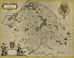
Background imageCountries Collection: Map of Valois, 1926 (print)

Map of Valois, 1926 (print)
3786712 Map of Valois, 1926 (print) by Blaeu, Willem (1571-1638) and Joan (1596-1673); Private Collection; (add.info.: by Willem and Joan Blaeu)

Background imageCountries Collection: Split. Beautiful romantic old town of Split during beautiful sunrise. Croatia, Europe

Split. Beautiful romantic old town of Split during beautiful sunrise. Croatia, Europe

Background imageCountries Collection: Puerto de la Cruz, fort in the harbor of the cityTenerife, Canary Islands, Spain

Puerto de la Cruz, fort in the harbor of the cityTenerife, Canary Islands, Spain

Background imageCountries Collection: Windows in the wild

Windows in the wild
Eden Antho

Background imageCountries Collection: Hawker Siddeley Nimrod R. 1 XV249

Hawker Siddeley Nimrod R. 1 XV249
Royal Air Force - Hawker Siddeley Nimrod R.1 XV249, of no.51 Squadron at RAF Wyton. A replacement R.1 modified for use as Electronic and Signals Intelligence gathering aircraft, to replace XW666


All Professionally Made to Order for Quick Shipping

"The King of Kings: A glimpse into the diverse tapestry throughout history" Daily Mail War Map, WW1: Unveiling the global impact of nations during the Great War. Anglo-Saxon 10th century world map: Tracing the ancient roots and territorial boundaries of countries. UK at night from space: Witnessing the vibrant glow that illuminates a nation's cities under a starry sky. World War One Combatants - Map of Europe: Exploring the intricate alliances and conflicts between countries during this tumultuous era. Scotland, UK, satellite image: Marveling at Scotland's breathtaking landscapes as seen from above. Poster advertising Austro-Hungarian War Bonds: Reflecting on how patriotism fueled financial support for countries in times of war. Map of Central Europe, World War One: Understanding the strategic importance and shifting borders within this pivotal region during WWI. Map of Europe after the Peace of Tilsit in 1807, from A Short History Of The. . : Examining geopolitical changes following peace negotiations that shaped European nations two centuries ago. Australia, satellite image: Beholding Australia's vastness and natural wonders captured by satellites orbiting high above Earth. "A Cooks Ticket will take you anywhere": Embracing wanderlust with an invitation to explore various countries through culinary adventures around the globe. Countries Travelled By The Apostles And Showing The Journeys Of St Paul Between Asia And Europe. : Tracing early Christian missionary journeys across continents, bridging cultures and nations. Intriguingly interconnected yet uniquely distinct – these captivating glimpses into different aspects surrounding 'countries' reveal their rich histories, geographical diversity, political dynamics, cultural exchanges, and timeless human aspirations for exploration and unity across our shared planet.