Home > Europe > Lithuania > Maps
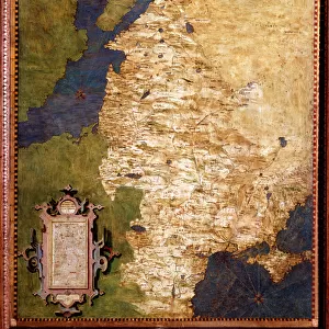
Map showing the partition of the Kingdom of Poland and the Grand Duchy of Lithuania, 1799

![]()
Wall Art and Photo Gifts from Fine Art Finder
Map showing the partition of the Kingdom of Poland and the Grand Duchy of Lithuania, 1799
1577229 Map showing the partition of the Kingdom of Poland and the Grand Duchy of Lithuania, 1799; (add.info.: Map showing the partition of the Kingdom of Poland and the Grand Duchy of Lithuania, 1799.); Universal History Archive/UIG
Media ID 38452332
© Universal History Archive/UIG / Bridgeman Images
1790s Lithuania Lithuanian Lithuanians Partition Poland Poland Polish Pole Polish
FEATURES IN THESE COLLECTIONS
> Europe
> Lithuania
> Posters
> Europe
> Lithuania
> Related Images
> Europe
> Poland
> Related Images
> Europe
> Russia
> Related Images
> Fine Art Finder
> Temp Classification
EDITORS COMMENTS
This historical map print showcases the partition of the Kingdom of Poland and the Grand Duchy of Lithuania in 1799, a significant event that reshaped the political landscape of Europe during the late 18th century. The intricate details on this map provide a glimpse into the complex territorial divisions between Poland, Lithuania, Russia, and other neighboring countries at that time.
The vibrant colors and precise cartographic elements highlight the strategic importance of these regions as well as the power dynamics at play among various European nations. This visual representation serves as a valuable educational tool for understanding how borders were redrawn and empires expanded through diplomatic agreements and military conquests.
As we study this map closely, we can appreciate the rich history and cultural heritage of Poland and Lithuania while also recognizing the impact of foreign intervention on their sovereignty. It is a reminder of how geopolitical decisions made centuries ago continue to shape our world today.
Whether you are a history enthusiast or simply intrigued by maps, this print from Bridgeman Images offers an insightful perspective on one of Europe's most tumultuous periods. Let your imagination wander through time as you explore this fascinating depiction of political intrigue and territorial disputes in 18th-century Eastern Europe.
MADE IN THE USA
Safe Shipping with 30 Day Money Back Guarantee
FREE PERSONALISATION*
We are proud to offer a range of customisation features including Personalised Captions, Color Filters and Picture Zoom Tools
SECURE PAYMENTS
We happily accept a wide range of payment options so you can pay for the things you need in the way that is most convenient for you
* Options may vary by product and licensing agreement. Zoomed Pictures can be adjusted in the Cart.