Home > Europe > France > Maps
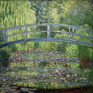
Map of France during the Hundred Years War (1337-1453). 19th century (engraving from a history book)
. 19th century (engraving from a history book)")
![]()
Wall Art and Photo Gifts from Fine Art Finder
Map of France during the Hundred Years War (1337-1453). 19th century (engraving from a history book)
ELD4913381 Map of France during the Hundred Years War (1337-1453). 19th century (engraving from a history book); Private Collection; Photo © The Holbarn Archive
Media ID 38423748
© © The Holbarn Archive / Bridgeman Images
100 Year War 100 Years War Hundred Years War 15th 15 Xv Xvth Fifteenth Century Geographical Map Isadora
FEATURES IN THESE COLLECTIONS
> Fine Art Finder
> Artists
> Albert Sébille
> Maps and Charts
> Early Maps
> Maps and Charts
> Related Images
EDITORS COMMENTS
This 19th-century engraving from a history book showcases a detailed map of France during the tumultuous Hundred Years' War (1337-1453). The intricate lines and shading on the map provide a glimpse into the geographical landscape of France during this pivotal period in European history.
As we study this historical artifact, we are transported back to the late Middle Ages, where political tensions and military conflicts shaped the destiny of nations. The borders and territories depicted on the map reflect the strategic importance of different regions as they were contested by rival powers.
The vibrant colors used to highlight various areas add depth and dimension to this visual representation of France during one of its most challenging eras. Each stroke of the engraver's hand tells a story of conquest, resistance, and resilience that defined an entire century.
Through this print, we gain insight into how geography played a crucial role in shaping the outcome of battles and campaigns throughout the Hundred Years' War. It serves as a reminder of both the complexity and significance of historical maps in understanding past events and their impact on our present world.
MADE IN THE USA
Safe Shipping with 30 Day Money Back Guarantee
FREE PERSONALISATION*
We are proud to offer a range of customisation features including Personalised Captions, Color Filters and Picture Zoom Tools
SECURE PAYMENTS
We happily accept a wide range of payment options so you can pay for the things you need in the way that is most convenient for you
* Options may vary by product and licensing agreement. Zoomed Pictures can be adjusted in the Cart.